A useful photograph answer tells the reader what is visible and how that evidence supports a conclusion. It does not turn every plausible story about a place into a fact. Rows of plants may support cultivation; they do not automatically reveal the crop, soil type, rainfall total or ownership of the land.
This lesson pairs an original invented landscape with a real, licensed ground photograph. They show different scenes. Use the first to practise precise position words and the second to test whether your method survives a less simplified view. Neither exercise asks you to guess a district from appearance.
Observation, inference and uncertainty
- Observation: a visible feature, such as three roofed structures or a strip of open gravel ground.
- Inference: an explanation supported by features, such as a track probably providing access to buildings.
- Uncertainty: something the image cannot establish, such as how many people use that track each day.
A strong sentence connects these stages: “The parallel rows in the left foreground suggest deliberate planting, although the species cannot be identified from the drawing.” The observation makes the inference testable. The final qualification stops it claiming more than the evidence allows.
Read position before naming an activity
Foreground means the nearer part of the scene, middle distance the intermediate part, and background the farther part. Left and right refer to the viewer’s view. These are not compass directions. A feature appearing at the top of an image is not necessarily north of another feature.
These regions are descriptive guides, not three compulsory strips of equal height. Perspective, overlap and apparent size help show depth. A ground photograph also does not normally have one uniform scale: a nearby small object can appear larger than a distant large one. Do not calculate a building’s real height without a valid supplied scale or reference and appropriate perspective assumptions.
View A: an explicitly constructed landscape
This is a teaching illustration, not a photograph, aerial image or record of a real farm. The key identifies broad feature types only. It deliberately supplies no crop names, building functions, soil properties, weather measurements or compass direction. Its neat shapes help you practise the boundary between what is shown and what is merely possible.
Worked case 1: land use in the left foreground
Question: What human land use is suggested near A? Give the evidence and one limitation.
Analysed answer: Cultivation is suggested by the repeated parallel rows of plants within a bounded patch in the left foreground. Their regular arrangement is stronger evidence of deliberate planting than simply saying the scene looks green. The drawing does not identify the species or show whether the plants are grown for food, sale or another purpose.
“Tea farming on fertile volcanic soil” would add two unsupported identifications. Even if that description sounds familiar from another exercise, it is not licensed by these rows. Background knowledge can help explain a feature after it has been identified; it cannot replace the missing identification.
Worked case 2: access and a building group
Question: Explain a likely function of feature B and describe the arrangement at C.
Analysed answer: The continuous unpaved track runs from the lower centre towards three nearby roofed buildings in the right middle distance. This supports the inference that it provides access to the building group. The three visible buildings are grouped close together in this view.
The scene shows a possible route, not traffic. No vehicle or person is drawn, so daily transport volume and the types of goods moved cannot be determined. Calling the group a whole nucleated settlement is also too strong: the frame could exclude other buildings. Describe the visible cluster first and qualify any wider settlement interpretation.
| Visible evidence | Supported inference | Still unknown |
|---|---|---|
| Regular rows at A | The patch is probably deliberately cultivated | Species, yield, irrigation and soil |
| Track B reaches the building group | The route likely provides access | Traffic, public access and journey frequency |
| Three roofed buildings at C | A small visible building cluster | Occupancy, building use and full settlement extent |
| Hill outlines at D | The distant land has relief | Altitude, rock type and slope angle |
Photograph B: inspect a real image
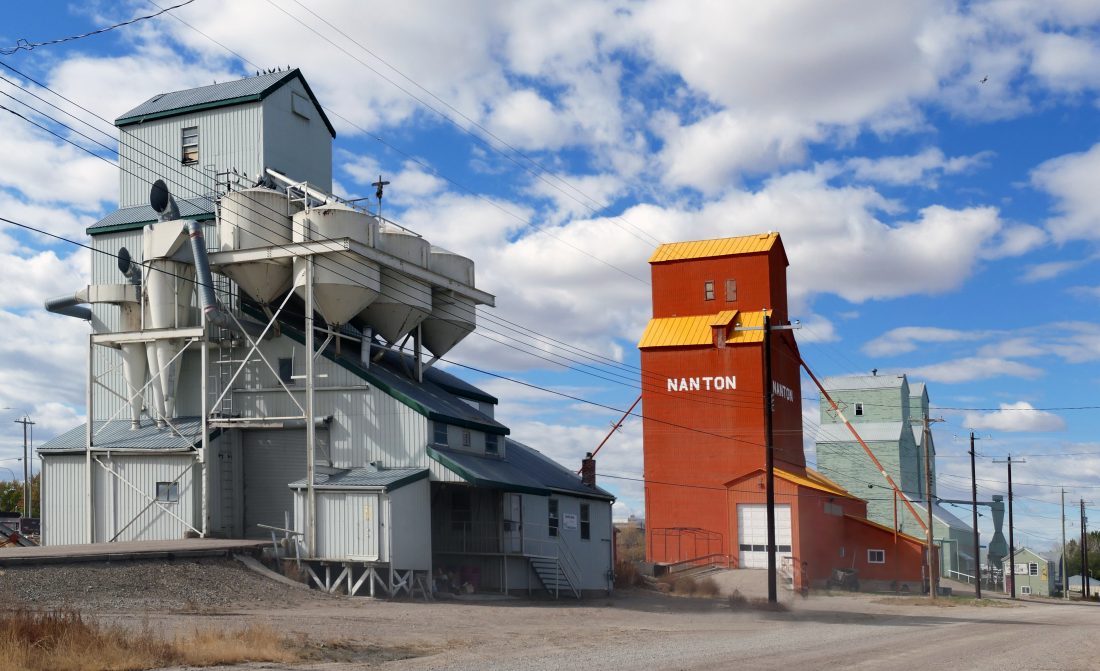
Text alternative: On the left is a large connected complex with raised container-like forms, supporting legs and sloping pipes or chutes. A separate tall red structure stands towards the right of centre. Smaller pale structures appear farther right. Wires cross overhead. Open gravel ground occupies the foreground. These features remain the basis of the following answer if the photograph cannot load.
Worked case 3: explain function without overclaiming
Question: What land-use interpretation is supported by photograph B, and what would you need to know before naming a product?
Analysed answer: The raised containers, chutes and large specialised structures suggest storage or handling of bulk material. This is more defensible than describing the buildings as ordinary houses. However, the photograph alone does not establish what material is stored or whether the equipment was operating when the picture was taken.
The image source calls the scene “Rural Farm Buildings”. Attribute that title if using it; do not pretend you deduced every part of it from the picture. Similarly, visible lettering is an observation, but a place name painted on a building does not by itself prove the camera’s exact coordinates. The task can be answered without identifying a locality.
For transport, the open roadway-like foreground suggests access space beside the buildings. The visible scene does not demonstrate delivery frequency, ownership, road classification or present-day conditions. One photograph records one view at one time, even when the file is accessed much later.
Draw a selective sketch with a key
Begin with a frame of similar proportions. Place the large left complex, central-right tower, smaller right structures and foreground band before adding details. Select a few visible outlines and label them clearly. Use a key for repeated symbols, but keep unproved functions out of the labels. “Large structure” is safer than “maize store” when maize is not identifiable.
The sketch simplifies photograph B; it does not add a north arrow, hidden roads or a numerical scale. Keep relative positions recognisable. Do not let a neat key turn the drawing into a plan map: it remains a view of features seen from the camera’s position.
Three practice tasks with solved answers
Practice 1: repair an overconfident land-use answer
A learner writes about view A: “The farmer grows maize because the soil is fertile.” Rewrite the answer using only supplied evidence.
Solution: “Regular rows of plants in the left foreground suggest cultivation. The drawing does not establish the crop or soil fertility.” This keeps the supported activity while removing an unidentified person, species and soil claim.
Practice 2: compare transport evidence
Give one transport-related observation from each view and explain what neither observation proves.
Solution: View A shows a continuous track towards the building group. Photograph B shows open roadway-like gravel ground in front of the structures. Both suggest access routes or space, but neither establishes the amount of traffic or the goods carried. Those would require additional observations or records.
Practice 3: assess settlement and a cannot-determine claim
Can you conclude that all three buildings in view A are occupied homes, or calculate the annual rainfall of photograph B’s location?
Solution: No. Roofed buildings do not reveal occupancy or purpose, and a single sky view is not an annual rainfall record. For settlement, describe the visible grouped buildings only. For rainfall, request observations over the stated period rather than using cloud cover as a numerical substitute.
Before you submit an interpretation
Underline every claimed fact and point to its evidence. If you cannot point to a visible feature or supplied caption, either qualify the claim, state what extra information is needed or remove it. Then check your sketch against the actual view. Good interpretation is precise about both what the image shows and where its information ends.
Read physical-process evidence in a ground view
A hill outline establishes relief but does not show how that hill formed. The original views below add visible material and surface relationships. They are invented teaching sketches, not photographs or records of a real site. Use the same observation–inference–limit method as for the real photograph above. No compass orientation, dimensions, event date, rainfall or land ownership is supplied.
Worked interpretation: movement down a slope
In C, the foreground pile contains angular blocks visually resembling the exposed jointed face immediately above it. A supported interpretation is that blocks detached from the face and accumulated at its foot through gravity-driven rockfall. The face is a likely source; the pile is material deposited downslope. This is a process explanation because it connects source, movement and accumulation.
The sketch does not show a block falling. Rockfall is an inference from the arrangement, not a directly observed event. It cannot establish the trigger, exact age, rate or whether movement is continuing. Calling the pile “yesterday’s earthquake debris” would invent both an event and a date. The National Park Service account of mass wasting identifies gravity-driven downslope movement and falling, bouncing or rolling debris as rockfall processes; it does not identify this invented scene.
Worked interpretation: removal and accumulation in one view
In D, the left bank is steep and recessed at the water’s edge, while the right shelf is low and made of loose sediment. These contrasting shapes are consistent with erosion at the left bank and deposition at the shelf. Flow can remove bank material, carry it and leave some where local conditions no longer keep it moving. A single view cannot measure those changes or prove that every shelf grain came from the opposite bank.
A mapped bend showing which side is inside and which is outside would strengthen a meander interpretation. That plan is not supplied here, so do not call left “outer bend” merely because it is left on the page. Nor can the visible water colour establish pollution, discharge or speed. The NPS meandering-stream explanation supports cut-bank and point-bar processes when the bend geometry is known; that extra geometry must not be silently added to this ground view.
Independent interpretation: test a stronger claim
A separate fictional view E shows a steep face with a cavity at its foot, angular blocks on the adjacent ground and water touching the face. A supplied later view from the same fixed camera position shows one formerly projecting block absent and a new similarly shaped block below. No time interval, scale or weather record is given. Write a four-part answer: visible change; best-supported physical process; one role water might have played; and one claim that cannot be established. Suggested classroom allocation: 4 marks, one for each justified part.
Explained response and marking
The projecting block is absent in the later view and a new similarly shaped block lies below (1). This supports detachment and downslope movement under gravity, followed by accumulation at the foot (1). Water contacting a cavity could have contributed to undercutting, but the pictures do not isolate that cause (1). Neither an annual retreat rate nor a rainfall/earthquake trigger can be calculated or identified without the missing evidence (1). Accept another clearly explained evidence limit. Do not award the process mark for “weathering” alone: breakdown in place does not explain the block’s changed position.
Carry this discipline back to photograph B: describe its actual visible structures and land-use evidence. The rockfall and bank models add physical-process reasoning; they do not change that photograph into a geomorphic scene.
Frequently asked questions
Can I identify a crop because it looks green?
No. Colour alone does not identify a crop. Use sufficiently distinctive visible evidence or a supplied reliable caption; otherwise keep the plant description general.
Does left in a photograph mean west?
No. Left is a position in the displayed view. Compass direction requires separate orientation information.
Is the teaching illustration a real place?
No. View A is an original invented scene. Photograph B is a separate licensed real image and is clearly identified as such.
Can the source title be used as visible evidence?
No. Attribute it as supplied background information. A title may add context, but it does not turn an unseen feature into something demonstrated by the pixels.
Should every building be labelled as a house?
No. Roofed structures may have many uses. Describe their visible form and arrangement before proposing a supported, qualified function.
Can a photograph provide an annual rainfall total?
Not by itself. Clouds or vegetation in one view do not supply a numerical annual record. A measured series for a stated period is needed.
Must my sketch copy every detail?
No. Preserve the main features, relative positions and relevant evidence. Use a clear key and avoid adding hidden features, guessed functions or unsupported map information.
Continue your revision
For the wider collection, visit the Geography topical revision collection. Check the listed contents and access conditions; some resources may require login or membership. This self-contained lesson does not promise a particular downloadable file.
 WhatsApp Us Now