Geography Notes Form 2
Geography Notes Form 2
Form 2 Geography
Internal Land Forming/endogenetic Processes
-Processes operating in the interior of the earth resulting in the formation of natural physical features or landforms.
They are caused by earth movements.
Examples of these processes are folding, faulting and Vulcanicity.
Formation of land forms by internal land forming processes is determined by:
• Nature and age of earth materials
• Type of movement involved
• Intensity and scale of movement involved
Crustal Earth Movements
– Displacement of the earth’s crustal rocks.
They are brought about by tectonic forces which originate and operate in the interior of the earth e.g. tensional forces (which operate along horizontal plane moving away from each other), compressional forces (which operate along horizontal plane moving towards each other), shear forces (which move past each other with unequal strength) and gravitational forces (which attracts things to the earths centre).
Earth movements are of 2 types:
1. Horizontal/lateral/orogenic movements
2. Vertical/epeirogenic movements
Horizontal Earth Movements
– Movements which act along a horizontal plane within crustal rocks.
They are caused by tensional and compressional and shear forces.
Effects
They cause:
• Strain and stretching of crustal rocks due to stretching caused by tensional forces which cause formation of cracks or faults.
• Squeezing and shortening of crustal by compressional forces rocks which cause them which also cause formation of faults.
• Crustal rocks to shear by slipping past each other or by dividing into layers which is caused by shear forces.
Results of Horizontal Earth Movements
– Results in the formation of the following features:
1. Faults
2. Rift valleys
3. fold mountains
4. Escarpments
5. Basins
6. Tilt blocks
7. Block mountains
Vertical Earth Movements
-Movements which occur along the earth’s radius or towards the earth’s surface or towards its centre.
Effects
Causes:
• Subsiding/sinking/downwarping or pulling of crustal rocks downwards.
• Uplifting/upwarping or pushing of crustal rocks upwards
• Tilting of crustal rocks or shearing in vertical direction due to grater uplift on one side.
Results of Vertical Earth Movements
1. Raised cliffs
2. Tilt blocks
3. Rift valleys
4. Fault scarps/escarpments
5. Plateaus
6. basins
Causes of Earth Movements
(a) Magma movement within the earths crust.
(b) Gravitational force
(c) Convectional currents in the mantle
(d) Isostatic adjustment
Magma Movement within the Earths Crust
• When magma moves with force pushing crustal rocks horizontally or vertically.
• When magma moves from reservoir and leaves empty spaces onto which crustal rocks are pulled inwards.
Gravitational Force
– When the attractive force of the earth pulls crustal rocks into empty spaces left after magma escaping from the reservoir.
Convectional Currents within Mantle
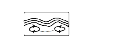
– When convectional currents in magma in mantle drug crustal rocks by friction.
Horizontal movement of currents cause horizontal movements while vertical cause vertical movements.
Isostatic Adjustment
-Rising of continental masses to restore the upset state of balance between sial and sima layers. -Isostacy is the state of balance between sial and sima layers.
It can be disturbed by erosion on continents and melting of continental ice sheets.
The reduced weight causes continental masses to rise.
Theories Explaining the Earths Movements
A theory is reasoned ideas intended to explain facts or ideas.
There are 2 theories which explain the earth’s movements namely the Continental Drift Theory and the Plate tectonics theory.
i)Theory of Continental Drift
Its proponent was A. Wegener.
It explains the origin of 6 continents.
It states:
• The earth was a single sialic land mass called Pangaea surrounded by a huge ocean called Panthalasa whose floor was a mass of sima.
• Pangaea broke into two parts called Laurasia (N. Hemisphere) which lay around equator and Gondwanaland (S. Hemisphere) which lay around south pole which were separated by a narrow ocean called Tethys (the present Mediterranean Sea).
• Laurasia broke into Laurentian Shield and Fennoscandia (Europe, Asia and N. America) and moved northwards to their present positions.
• Gondwanaland broke into Africa, Australia, S. America and Antarctica and India subcontinent.
• Africa and India drifted northwards.
Evidences Supporting the Theory
1. Fitting of western coast of Africa and S. America into a jigsaw.
2. Discovery of coal 40◦N and 55◦N which was formed by burying of tropical vegetation.
3. Considerable displacement of rocks along some faults e.g. along the Great Glen Fault of Scotland.
4. Cape and Buenos Aires folds resemble one another by having east west trend.
5. Red sea shores show evidence of having undergone lateral displacement an indication that it was formed by movement of the earth’s crust.
6. Evidence of ancient Glaciation to the south of equator in Africa in Madagascar and India where there is presence of ancient glacial deposits suggesting these areas were once around south pole.
ii)Plate Tectonics Theory
It states that:
• The earths crust is made of blocks called plates.
7 Large Ones
1. Eurasian plate
2. Australian plate
3. Africa plate
4. Antarctic plate
5. N. American plate
6. S. American plate
7. Pacific plate
Smaller Ones
1. Indian
2. Arabian
3. Caribbean
4. Cocos
5. Somali plates
6. Juan de Fuca
7. Nazca
8. Philippine
9. Scotia
• These plates are two types : tectonic plates:
1. Oceanic plates which form major areas of the ocean floor including coastal lowland.
2. Continental plates which form the bulk of the continental land mass.
• The plates float on molten mantle layer called Asthenosphere.
• The plates move relative to each other due to convectional currents in the mantle.
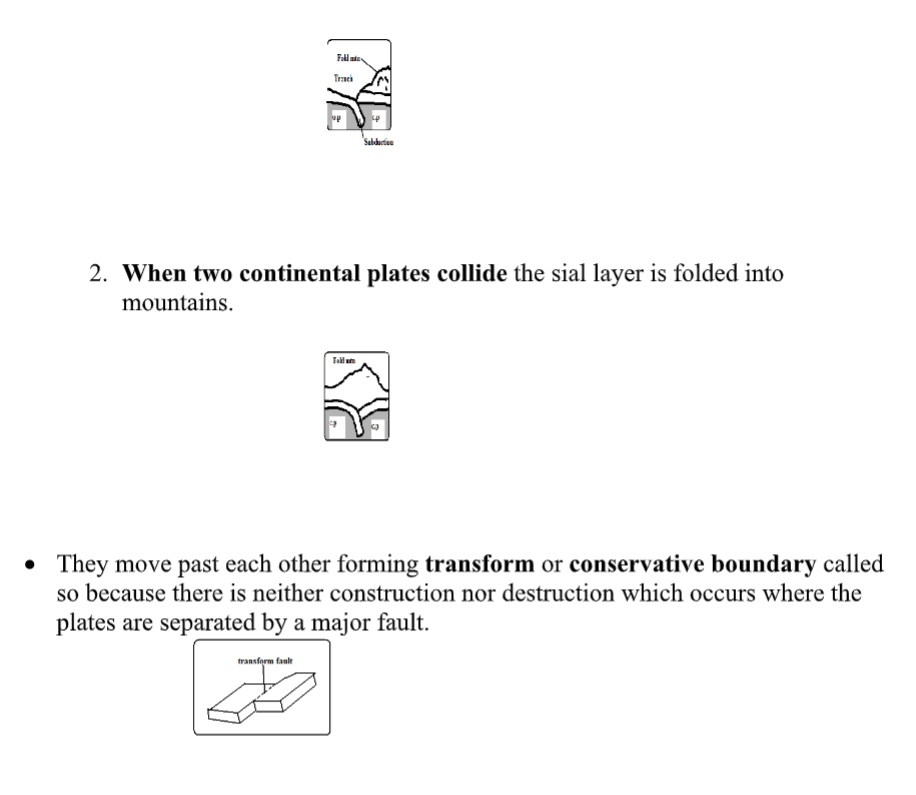
• They move away from each other forming extension or constructive boundary called so because magma fills the space between.

• They move towards each other forming compressional or destructive boundary called so because materials between are crushed.
The movements of those two types of plates have the following effects:
1. When two oceanic plates meet
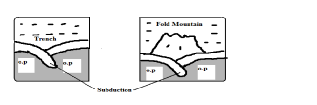
• There is subduction and the ocean floor is pulled inwards forming a trench e.g. Java Trench .Subduction is the passing of edge of one plate beneath the edge of another.
• Sediments on the sea floor in the region of subduction are compressed to form Fold Mountains.
1. When an oceanic plate meets a continental plate the edge of the oceanic plate slides beneath the continental plate in a movement called subduction.
• Sediments on the sea floor in the region of subduction are compressed to form Fold Mountains.
• Fold Mountains are also formed at the edge of the continent when the sial layer is compressed.
• The edge of the oceanic plate bends into the mantle forming a trench.
2024 FORM 1 2 3 4 REVISION RESOURCES
FORM 1 2 3 4 TERM 1 2 3 OPENER , MID AND END TERM EXAMS
1995-2024 KCSE KNEC PAPERS QUESTIONS,ANSWERS AND REPORT
2008-2024 KCSE FORM 4 COUNTY MOCKS
FORM 1 2 3 4 SCHEMES OF WORK
FORM 1 2 3 4 LESSON PLANS
FORM 1 2 3 4 CLASS REVISION NOTES
FORM 1 2 3 4 TERM 1 2 3 HOLIDAY ASSISNMENTS
FORM 3 4 SETBOOKS STUDY GUIDES
FORM 1 2 3 4 TOPICAL TESTS
FORM 1 2 3 4 REVISION BOOKLETS
LIFE SKILLS NOTES
FORM 1 2 3 4 SYLLABUS
KENYA SCHOOL CODES
HOW TO REVISE AND PASS EXAMS
GUIDANCE AND CONSELLING NOTES
CLICK HERE TO DOWNLOAD ALL LATEST 2024 KCSE REVISION MOCKS
KCSE COUNTY MOCKS DOWNLOADS 2024
2023 KCSE COUNTY MOCKS DOWNLOADS
- 2023 KAPSABET BOYS POST MOCK
- PANGANI MOCK KCSE 2023
- KCSE 2023 LAINAKU II FORM 4 JOINT MOCK
- KENYA HIGH POST MOCK
- KALA MOCK =Password is- subjectcodeKALA2023
- KCSE 2023 SAMIA JOINT MOCK
LANJET 2023 EVALUATION MOCK
2023 EVALUATION MOCK nyandarua trial 4
2023 EVALUATION MOCK nyandarua trial 3
KCSE 2023 MOCKS NYARIRA CLUSTER EXAMS
KCSE 2023 CEKANA MOCKS
KCSE 2023 ACHIEVERS JOINT MOCK
- KAPSABET 2 MOCK 2023
- MOKASA 2 MOCK 2023
- 2023 Mang’u high revision mock
- FORM 4 TERM 2 BAKALE EXAM
CATHOLIC DIOCESE OF KAKAMEGA MOCK
- BSJE JOINT MOCK EXAM 2023
- MARANDA HIGH SCHOOL MOCK JUNE
- KCSE 2023 mock Nginda girls
- 2023 Kcse mock Wahundura
- 2023 Kcse mock set 22
KCSE 2023 KASSU MOCK EXAMS
- 2023 KCSE EAGLE TRIAL 1 MOCK
- 2023 lainaku revision mock
- 2023 FORM 4 evaluation exams set 18
- 2023 FORM 4 evaluation exams set 17
- 2023 FORM 4 evaluation exams set 16
LUGARI CONSTITUENCY -MOCK 1
- 2023 KCSE FORM 4 EVALUATION TEST
2023 mokasa mocks revision exams
- SUKELLEMO JOINT PRE-MOCK EXAMS
- Mumias west pre mock kcse exams
- 2023 SUNRISE PRE-MOCK
- 2023 kcse arise and shine pre-mock
- MECS CLUSTER JOINT MOCK EXAM
- Chogoria murugi zone pre-mock
- MOMALICHE 2 EXAMS PRE MOCK
- ASUMBI PRE MOCK EXAMS 2023
- 2023 MARANDA HIGH PRE-MOCK
- KAPSABET INTERNAL TRIAL 1 2023
- FORM 4 EVALUATION TEST 2023
- 2023 FORM 4 evaluation exams
Mock exams and pre-mock exams are practice tests that are taken before the actual exams.
2022 COUNTY MOCKS 38 EXAMS
2021-22 COUNTY MOCKS 36 EXAMS
2020-21 COUNTY MOCKS 24 EXAMS
2019 COUNTY MOCKS 44 EXAMS
2018 COUNTY MOCKS 23 COUNTIES EXAMS
2017 COUNTY MOCKS 25 COUNTIES EXAMS
2016 COUNTY MOCKS 16 COUNTIES
2015 COUNTY MOCKS 20 COUNTIES
2008 , 2009 , 2010 , 2011 , 2012 , 2013, 2014 COUNTY MOCKS 25 COUNTIES
2023 KCSE COUNTY MOCKS Mock exams and pre-mock exams are practice tests that are taken before the actual exams.
They are designed to help students get a sense of what to expect in the real exam and to identify areas where they need to improve.
The purpose of taking mock exams is to help students build confidence, develop test-taking strategies, and identify their strengths and weaknesses.
Pre-mock exams are usually taken a few weeks or months before the actual exam, while mock exams are usually taken closer to the exam date.